Things are different now.
Eighty years ago environmental regulations were a bit looser in the oil and gas industry. A good look at the picture above and you can see just how loose.
We have come a long way since the days when the Mary Sudik #1 ran wild for eleven days and turned Crutcho Creek into a crude oil facility. Most of our modern environmental regulations came on line in the early 1980’s and today the Oklahoma Corporation Commission requires strict environmental practices such as mechanical integrity tests and lined pits. The memories of the oil patch where you could actually walk on patches of crude oil have faded away much like the photographs of the era.
Unfortunately, some of that stuff is still hanging around. The problems usually associated with old oil and gas operations are salt water. Salt water is pumped up with the oil and gas from geologic formations far below the surface. This salt water is separated from the oil and gas at the production site.
Modern oil and gas operations usually haul the salt water to an injection well facility. But in bygone days the water may have been just dumped on the ground, or put in leaking pipeline collection systems. Drilling pits were unlined in those days and waste was dumped into them, leaking into the groundwater. A well site abandoned forty or fifty years ago may now be a wheat field without a trace of anything to remind you that there once was a busy industrial operation there.
But what lies beneath in many places is the problem. Salt water still exists in buried pipelines, old pits have been covered over with dirt, and the occasional unplugged may have contaminated the groundwater in many places in Oklahoma. This is why the Oklahoma Corporation Commission has begun the process of mapping out areas of old oil and gas wells which may impact groundwater.
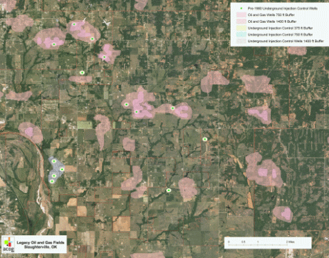 Example Legacy Oil and Gas Map
These legacy oil and gas maps detail areas where pre-1980 oil and gas activity has occurred. As a result of the industrial activity in these areas, groundwater contamination may have occurred and further study is recommended, especially for water well drillers. These maps are the basis for a proposed change in domestic water well construction standards, which would mandate a thirty foot casing in legacy oil and gas areas.
City planners, property owners, and people interested in drilling water wells also need to review these maps. It may help to avoid locating a well above an old salt pit! At the present time the Oklahoma Corporation Commission has mapped the legacy oil and gas areas on the central Oklahoma Aquifer in Logan, Oklahoma, Cleveland, and Pottawatomie Counties. For more information, contact Patricia Billingsley at the Oklahoma Corporation Commission, or John Harrington at ACOG.