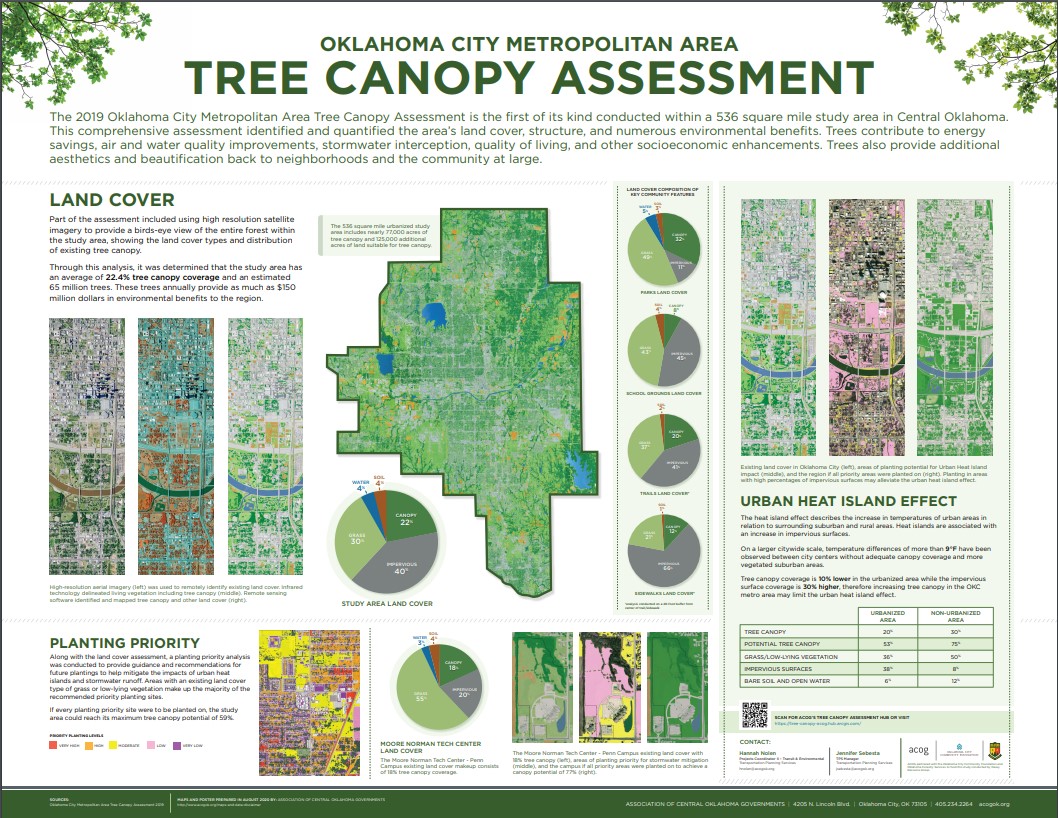
The 2019 Oklahoma City Metropolitan Area Tree Canopy Assessment is the first of its kind conducted within a 536 square mile study area in this part of Oklahoma. This assessment was conducted during the spring and summer of 2019 and included portions of or all boundaries within the communities of Oklahoma City, City of Edmond, City of Bethany, City of Moore, City of Mustang, Midwest City, City of Yukon, Lake Aluma, Town of Forest Park, Del City, City of Spencer, The Village, Nichols Hills, City of Warr Acres, Valley Brook, City of Norman, Woodlawn Park, Smith Village, and Tinker Air Force Base.
This comprehensive assessment identifies and quantifies the area’s land cover, structure and numerous environmental benefits, which include energy savings, air and water quality improvements, stormwater interception, quality of living, human benefits and other socioeconomic benefits. Trees also provide additional aesthetics and beautification back to neighborhoods and the community at large.
In recognition of this valuable resource, Oklahoma City Community Foundation (OCCF) in partnership with the Association of Central Oklahoma Governments (ACOG) and Oklahoma Forestry Services contracted with Davey Resource Group Inc. (DRG) to conduct this assessment.
Through this analysis, it was determined that the study area has an estimated 65 million trees annually providing as much as $150 million dollars in environmental benefits within this study area.
Staff Contacts
Hannah Nolen, AICP
Mobility & Planning Manager
Jennifer Sebesta
TPS Division Manager
Hub Site
The hub site contains all information and data related to the 2019 Oklahoma City Metropolitan Area Tree Canopy Assessment including:
- Web maps
- Narrative story map
- Pdf of the full report and supporting documents
- Data available to download
Land Cover Webmap
This webmap shows the results of the Oklahoma City Metropolitan Area Tree Canopy Assessment land cover analysis, a result of using high resolution imagery and infrared technology to provide a birds-eye view of the entire study area.
The 536.4 square mile study area’s land cover is comprised of:
- 22.4% tree canopy
- 30.1% impervious surface
- 40.1% grass and low-lying vegetation
- 3.8% bare soil
- 3.6% open water
The data developed during this assessment will become an important part of the GIS database for the region and will provide a foundation for developing community goals and urban forest policies.
With this data, managers can determine:
- The study area’s progress towards local and regional canopy goals
- Changes in tree canopy over time and in relation to growth and development
- The location and extent of canopy at virtually any level
- The location of available planting space to develop strategies for increased canopy in underserved areas
This webmap includes summary layers focused on the land cover composition of parks, trails, school grounds, neighborhoods, council wards, and more.
Priority Planting Webmap
This webmap shows preferred planting sites within the Oklahoma City Metropolitan Area for the purpose of increasing tree canopy in the region.
Considering the existing tree canopy and areas of low-lying vegetation that have the potential to support tree canopy coverage, the overall canopy potential for the study area is 59.1%.
Within the study area, Davey Resource Group identified over 125,000 acres of preferred planting sites. The analysis excluded sports fields, cemeteries, and other sites not suitable for trees.
Each planting location was assigned a priority ranking for overall benefit, reducing stormwater runoff, and mitigation of the urban heat island effect.
While available planting sites may ultimately be planted over the next several decades, the trees planted in the next several years should be planned for areas of greatest need and where they will provide the most benefits and return on investment first.